Day 1: Monday International Airport – Chameleon Backpackers Guesthouse -50km
Today we are collected at the Hosea Kutako International Airport, and brought into Windhoek to Chameleon Backpackers, our accommodation for the night. Chameleon Backpackers is centrally located for a quick walk into the city centre, or stay in-house and ask for the nightly meal or pizza options.
Chameleon Backpackers is a great place to meet and chat with other guests or just enjoy an evening meal by the bar or pool.
Day 2: Tuesday – Windhoek – Halali, Etosha National Park – 500 km
You will be collected from Chameleon Backpackers at 07:00 and transferred to Chameleon Backpackers for a short pre-departure meeting.
Heading north from Windhoek, we stop briefly at the small town of Otjiwarongo to gather some last-minute supplies before continuing on to Etosha and we enjoy a light lunch pack whilst “on the move”. We enter Etosha National Park and game drive our way to our overnight accommodation at Halali Camp.
Etosha is huge, just over 22,000 square km and is home to 114 species of mammal, 350 species of bird, 110 species of reptile, uncountable numbers of insect and, somewhat bizarrely, one species of fish. There are good chances of spotting many of these different creatures as we tour through the park, stopping at the various waterholes along our way.All visitors must be in camp by sunset and we aim to arrive at our lodge at Halali just before sunset and with time to settle into our rooms, with en-suite bathroom and tea/coffee facilities.
The name for Halali is taken from a bugle refrain that was originally used during sport hunting with horse and hounds in Europe. The bugler would sound the Halali to signify that the hunt was over. This was considered appropriate for Etosha as inside the protection of the National Park, the hunting of animals is over forever. The ‘game show’ in Etosha doesn’t stop when the sun goes down. All the Etosha camps have floodlit waterholes for extra game viewing opportunities. The Halali waterhole is called Moringa, after the moringa trees that are abundant here, and it is located within walking distance from our accommodation. A visit, or two, is highly recommended this evening as we can expect many species to visit Moringa during the night and this waterhole is known to be very popular with elephant and the critically endangered black rhino.
Day 3: Wednesday – Halali – Etosha Village near Anderson gate – 70 km
We have the whole day to explore Etosha and we want to make the most of it. The park gates open at sunrise and we aim to be on our way just as the sun breaches the horizon. Early morning is usually a productive time for game viewing and first thing in the morning is a good time to catch big cats returning from the hunt.
We return to Halali for breakfast and to load our vehicle before heading out into the park once again in search of big game. Etosha is desert landscape and water is the most scarce natural resource.
There are however numerous waterholes here, both natural and man-made, and our game driving technique is to take in as many as of these possible. Here we hope that the game will come to us as the thirsty animals attend for a much needed drink.
On our way today we will stop to have a closer look at the Etosha Pan. The name Etosha translates as ‘great white space’ but this name does not do justice to the immensity of the pan. Over 4,700 square km of dazzling white mineral pan, so big that it can be seen from space.
We exit Etosha at the Anderson gate close to sunset and it is just a short drive to or accommodation in a comfortable spacious twin share room with modern en-suite bathroom facilities. An ideal space to sit back, relax and enjoy the beauty that surrounds you. A fantastic dinner is prepared by our guide this evening.
Day 4: Thursday – Etosha – Swakopmund, Hotel A La Mer – 510 km
After breakfast we aim to be on the road by 07:30 today. We are heading for the Skeleton Coast and we are taking the scenic route. We first head south on the main road, passing the small town of Outjo, then onwards towards the west and picking up the gravel road as we travel through an area known as Damaraland.
Damaraland is famed for its scenery, mountains, open grasslands, tall koppies, (small hills), of round pink granite boulders, wide open spaces and big sky. We also have a chance to meet some of the locals as there are several places along our road today where we can find informal shops selling locally made, hand crafted souvenirs. Represented here we usually find ladies from the Himba, Herero and Damara tribes and most often they are wearing their traditional dress. Here we can interact with some of the colourful local characters who live in this harsh environment. Making a small purchase here is a good way to inject some cash directly into the local economy.We continue on through the beautiful landscape, making a stop for a light picnic lunch, under the shadow of Namibia’s highest mountain, the Brandberg. Rising up from the desert floor, this giant monolith is 2,573 m above sea level and is formed of pink tinged granite. We continue our journey west and soon arrive at the coast and the chilly Atlantic Ocean. The whole coastline of Namibia is known as the Skeleton Coast and it is easy to see why this barren seaboard is so named with its forbidding mountains and barren beaches. The wind, the waves and the huge fog banks all conspire to push ships onto the beach. The countless mariners that, in olden times, found themselves shipwrecked here faced the stark prospect of no fresh water, no food, no rescue and a slow death by exposure. Their Shipmates who went down with their ship were thought to be the lucky ones.
Heading south on the coast road our next stop is a more recent shipwreck. 15 km south of the small town of Henties Bay a fishing trawler, The Zeila, was beached in 2008. She was an old vessel that had been sold for scrap and was under tow at the time. The cable snapped and, as so many vessels before her, she was caught in the swell and currents and ended up on the beach. She lays quite close to the shore and is well positioned for photos.
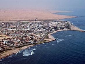
We complete the final leg of our journey into Swakopmund, we check into our accommodation Salty Jackal Backpackers Swakopmund was founded by Captain Kurt von François of the imperial colonial army of the German empire in 1892. (He also founded Windhoek in 1890). It is an interesting town to say the least, bounded to the north, the east and the south by the mighty sand dunes of the Namib Desert and to the west by the Atlantic Ocean. There are still many examples of colonial German architecture to be seen and the German language is still widely used. Swakopmund boasts some truly excellent restaurants and again your guide will be able to help you with recommendations.
Day 5 – 11: Friday-Thursday Salty Jackal Backpackers, Swakopmund
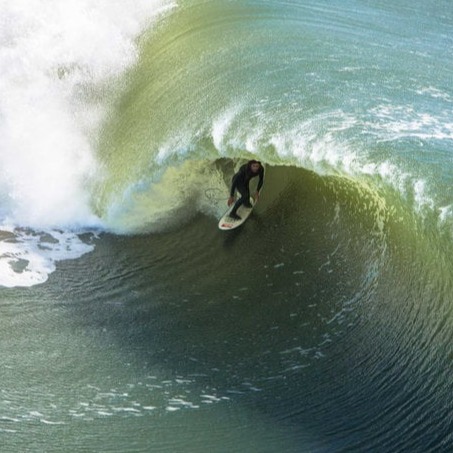
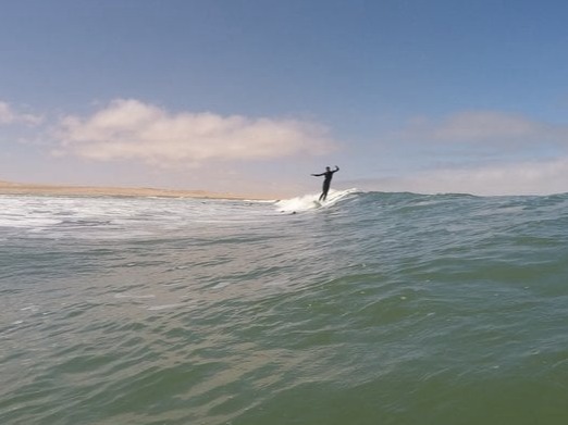
For the next 7 days, we will enjoy an early breakfast before heading to the beach for a surf session with our ISA qualified surf coach or guide. We are at the mercy of nature, so there can be days with perfect conditions where 2 sessions make sense in one day and there can be days where the waves are too dangerous for your surf level and we have to skip a day.
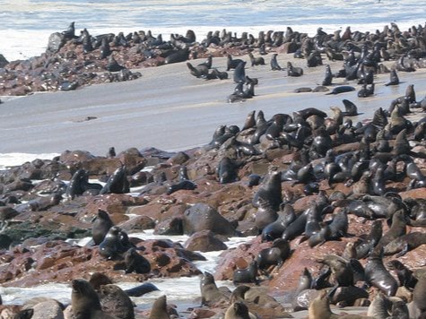
The coastal town of Swakopmund has many more adventure activities on offer and this is the perfect time to try some quad-biking, paragliding, windsurfing, scenic flights or angling. Visit the Cape Cross seal colony, or go on a dolphin cruise in nearby Walvis Bay, which we arrange for you as requested. Most sessions take place in the mornings and in our area, while in certain conditions we go on a full day adventure to spots further away from Swakopmund. Be ready for untouched wilderness – surrounded by jackals & seals, usually dolphins and sometimes even whales & penguins.
With the surfing usually happening in the morning and followed by a world-class coffee in one of the town’s cafes to unwind and share surf stories, you’ll have your afternoons for chilling, activities, yoga classes or exploring the town & nearby nature. The evening leaves us with time for a walk in the sand dunes or a cold drink by the ocean to kickstart you into some Swakopmund nightlife. Dinners are often spent together around a BBQ fire, in a beer garden with live music or at a delicious wine bar & pizzeria.
Day 12: Friday – Swakopmund – Sesriem Campsite – 350 km
Departing Swakopmund no later than 11:30 we head east into the desert. We first cross the Namib gravel plains, large areas of flat and seemingly barren terrain broken up by huge mountain inselbergs. We have two mountain passes to traverse this afternoon, first is the mighty Kuiseb Pass and we follow the road from the top of the mountains, dropping steeply down into the canyon carved over eons by the Kuiseb River on its way to debouch into the ocean at the port town of Walvis Bay. We climb up from the banks of the river and over the pass, travelling through the mountain peaks and on to the second, smaller canyon of the Gaub River, a tributary of the Kuiseb. We emerge from the mountains onto a flat road and almost immediately we cross the Tropic of Capricorn at 23.5 south degrees. There is a signpost at this auspicious spot and we stop along the road for photos.
From here we continue on through the desert landscape to the tiny town of Solitaire where we can stretch our legs and sample the apple pie that has made this homestead famous. Onwards again to our destination for today, the gateway to the dunes and Sossusvlei at Sesriem.
We make our campsite under a huge, ancient camelthorn tree from where we can, in anticipation of our day tomorrow, glimpse the towering red dunes of the world’s oldest desert.
Day 13: Saturday – Sesriem – Sossusvlei – Sesriem – 120 km
Sunrise in the dunes is the name of the game this morning and that means a pre-dawn start. Our first stop will be at dune 45, so named because it is 45 km from Sesriem, and we cover this first distance in darkness and early morning twilight.
The best time to photograph the dunes is around sunrise and sunset. This is when you can see towering sand dunes illuminated a glowing orange, apricot red on one side and swathed in shadow on the other. The depth of field is amazing at this time of day.
We arrive at Dune 45 and climb to a vantage point for sunrise, watching as the colours grow and change with the ever altering light. Back to the vehicle for a quick breakfast and we carry on for the last few kilometres to the 2×4 car park where all 2 wheel drive vehicles have to stop. From here we enter the ancient Tsauchab River-bed for the last 5km leg to Sossusvlei itself.
The Tsauchab River is ephemeral, it only flows seasonally, when there is enough rain, and for the most part the river-bed is dry. Eons ago, during these rare floods the Tsauchab sometimes received enough water to flow all the way to the Atlantic Ocean. However, as the millennia passed and the dune fields began to form, (around five million years ago), wind -blown sand invaded the river-beds. The rivers became more and more constricted by sand until eventually the occasional floods could not break through the sand barriers that had been erected by the wind. The valley we drove along this morning in the darkness is kept free of sand by the Tsauchab but Sossusvlei is now permanently waters end. Sossusvlei does still sometimes flood, (perhaps once in a decade). After good rains in the Naukluft Mountains where the river rises, Sossusvlei can become inundated, and the lake that this creates can last for many months, but no longer can the river find its original path to the Atlantic.
There is a 4×4 shuttle service that will transport us through the sandy terrain of the river-bed. We will visit Dead Vlei, an ancient pan completely surrounded by sand, that is strikingly populated with dead, skeletal camelthorn trees. These trees have been a feature on this landscape for over 1000 years. Sossusvlei is almost surrounded by dunes, just one narrow path kept open by the Tsauchab River.
We have time to explore the area on foot and to climb one of the highest dunes in the world, some towering 300 m above us, the views are breath taking and justly famous.
We drive back to Sesriem for lunch and perhaps a dip in the swimming pool and in the afternoon we take a short excursion to see the Sesriem Canyon.
Only four km from our campsite, this canyon has been carved out of the landscape by the Tsauchab River. Around two million years ago there was an ice age in Europe. This caused glaciers to form and resulted in a worldwide drop in sea level. The knock on effect of this at Sesriem Canyon was that it increased the length and waterflow of the Tsauchab River. This greater force of water allowed the Tsauchab to begin cutting through the terrain resulting in the canyon we can see today. We can easily walk into the river-bed, it is usually much cooler in the canyon and we can follow the river for some way along its journey to Sossusvlei.
In the late afternoon there is one further option with which to close our time in the world’s oldest desert. A short drive will take us to Elim Dune, for the best golden light before sunset. From here, if you would like to, it is a relatively short walk back, through the desert, to our camp.
Day 14: Sunday – Sesriem – Klein Aus Vista – 350 km
We have a scenic drive today through ever changing desert scenery, mountains and open grassland. We are continuing our long drive south and our destination is the tiny community of Aus, located in the Aus Mountains above the plains of the Namib Desert.
Aus was formally the site of a prisoner of war camp set up by the South African army to house German prisoners during the second world war.
Our actual destination today is Klein Aus Vista located just outside Aus and just inside the private Gondwana Sperrgebiet Rand Park. We aim to arrive in the early afternoon and set up camp, giving us time to stretch our legs on the un-guided hiking trails on the property.
The landscape is wide open vistas and we are hoping for a spectacular sunset.
Day 15: Monday – Klein Aus Vista – Luderitz – Klein Aus Vista – 250 km
We again start early but with the luxury of a proper sealed tar road today. We travel through grasslands and wide open desert scenery on our easy drive towards the ocean.
Desert adapted horses run wild in this area and we need to keep a good look out for these amazing creatures. Horses are not a part of the true desert ecosystem and their origins here remain open to speculation. Perhaps they are descended from the German cavalry lines during the first world war. It is also documented that Hans Heinrich von Wolf, owner and resident of Castle Duwisib in 1909 was a keen horse breeder. Maybe the origins of the horses today come from his blood stock escaping their stables at Duwisib. Whatever their true history it is a privilege to see these animals in their wild habitat.
We are en-route to the ghost town at Kolmanskop, located about 15 km from the port town of Luderitz. For centuries, amongst early mariners, there have been rumours and stories of untold riches to be found on one far flung coast or another. Most often these claims turned out to be just stories but in the case of the far south-west of Namibia, it happened to be true. When diamonds were first discovered here you could literally walk along the beach and fill your pockets with these precious stones. The first diamond mine was called Kolmanskop. Founded in 1908, it was built in the architectural style of a German village and was supplied with the most modern amenities of the age. There was a hospital that boasted the first x-ray machine in southern hemisphere, a power station, school, ball room and ice factory. The decline of Kolmanskop started around 1920 when the diamonds began to run out. Then in 1928 the richest diamond deposits that the world had, at the time, ever known were discovered 270 km away to the south at the Orange River. Kolmanskop became deserted and so started the slow reclamation of the town by the desert. Still a striking sight today, we will stop at Kolmanskop for a guided tour of the town and the opportunity to photograph this unique and interesting site.
On departure from Kolmanskop we quickly cover the last few kilometres to Luderitz itself, well known for its unique and colourful colonial-style buildings. We drive out on to the Luderitz peninsula and enjoy the scenery on way to the historical monument at Diaz Point. As at Cape Cross, the first sign of European interest in this land was from the Portuguese and in this case it was the navigator Bartolomeu Diaz who landed here in 1487 and caused a stone cross to be erected. This time the name given to the area was Angra das Voltas or ‘Bay of Tacks’ with reference to the many times Diaz had to ‘tack’ his ship against the southern gales. Luderitz is still today one of the windiest places on planet earth, so some things at least have not changed over the centuries.
We head back to our accommodation at Klein Aus Vista, taking a second opportunity to see the desert horses and arriving in time for a sundowner at Klein Aus Vista.
Day 16: Tuesday – Klein Aus Vista – Quiver Tree Forrest – 550 km
A long drive today but we take advantage of the tar road for the first part of the morning. We are heading east but we will soon turn south again to complete our traverse of Namibia’s southern region. Our first main stop this morning will be the incredible Fish River Canyon located in the /Ai-/Ais Richtersveldt Transfrontier National Park. We enter the park at the Hobas gate and from there it is only a short drive to the main lookout point over the Fish River Canyon.
Second only in size to the Grand Canyon in Arizona, the vistas across this most immense of nature’s sculptures are breath taking. From our vantage point high up on the plateau we overlook the so called ‘Hell’s Bend’ which takes the form of a huge meander along the course of the Fish River.The canyon itself is around 160 km long, 27 km wide at its widest point and in places 550 m deep. The origins of the Fish River Canyon can be traced back to about 1,800 million years and the formation of the canyon itself can be attributed to just about every possible geological force known to man. Huge seismic forces, volcanic eruptions, earthquakes, glacial activity, relentless erosion of every kind and finally, deepened by the Fish River that we can see glinting in the sunlight far below us. This is a perfect example of tortured rock that inspires our awe by its sheer massive size.
It is hard to leave such an impressive sight but we journey onwards, turning our heads to once again to the north as the canyon marks the end of the southern leg of our trip. We are en-route to Keetmanshoop, the main commercial and political centre of Namibia’s south. A short stop here and then on to our overnight camp at the Quiver Tree Forrest.
Quiver trees are Namibia’s National Tree and are so named because the San tribes of Southern Africa used to strip the scaly bark from these trees and construct from it a narrow cylinder. From this they would manufacture a quiver in which to keep their poisoned arrows. A quiver tree, despite it’s very tree like appearance, is in fact not a tree at all. It’s real name is Aloidendron Dichotomum, (formally Aloe Dichotoma), and so is an aloe, and an aloe is a plant and not a tree. This does not diminish the impact they have on the landscape, weird and wonderful shapes abound from this collection of around 250 quiver plants/trees/aloes? The oldest specimens here are estimated to be about 200 years old and it is thought that they can achieve an age of up to 300 years. Dating a quiver tree however is difficult, as it does not have rings of bark to count, the centre of the tree is fibrous and there is really no established method of ageing.
This is the last night of our safari and time to reflect on our amazing adventure as we sit around our camp-fire one last time.
Day 17: Wednesday- Quiver Tree Forrest – Windhoek Chameleon Backpackers 500 km
We head north today and we have the luxury of the main tar road for our whole journey, no gravel road ‘African Massage ’to contend with, as we head back to Windhoek.
Namibia is so rich in interesting things that it is impossible drive for any great distance without passing places of interest and there are several worth mentioning along the way today.
After about 80 km from Keetmanshoop, in the distance and off to the west we can see a tall mountain peak. This is Brukkaros, another volcano but quite an unusual one. Brukkaros was formed around 180 million years ago when molten magma from deep below the surface was pushed upwards until it intruded into the overlaying, relatively soft, sedimentary formations that made up the surface. Molten magma intrusions are common in world-wide geology, but what makes Brukkaros unusual is that in this case the upward moving magma hit an underground lake leading to a huge explosion powered by super-heated steam.
What was left formed hollow cave, that was once the magma chamber, but with an overhead ‘caldera’ forming a partial roof. 80 million years later the weight of the caldera was too much and collapsed into the magma cave. Brukkaros is 1,590 m tall at its highest point, the collapsed caldera measures about 4 km in diameter. The mountain itself is 650m higher than anything else in the area and the crater floor is 350 m below the rim. Steam formed volcanoes are very rare, and although Brukkaros is too far away to be included on this itinerary it is an interesting landmark to look out for on our drive today.
About 150 km into our long road today we will pass a signpost to a place called Gibeon. Again, like Brukkaros, Gibeon is too far away to be included in this itinerary, but there is an interesting story that is worth telling. Near here, in ancient prehistoric times, the area around what is now Gibeon was subjected to a Meteor strike of very significant proportions. The meteor, when intact, was thought to measure 4 x 4 x 3 meters and we know that it was made of solid metal. As it entered the earth’s atmosphere the metal began to melt and in due course the meteor fragmented in a huge explosion scattering chunks of molten metal across the countryside. Meteor’s from this event have been found as far away as Brukkaros Volcano to the south and as far away again towards the north, but the greatest concentration of meteor material has been found in and around Gibeon.
If you have time in Windhoek after our safari it is worth going to Post Street Mall in the city centre where you will find a public display of Gideon Meteorites
Still heading ever north our journey today takes us through the small centres of Mariental and Rehoboth and we will stop along the road today for a light lunch. We aim to be back in Windhoek in the late afternoon where we will be dropped at Chameleon Backpackers. Tonijghts dinner is at own expense in one of the many restaurants that Windhoek have to offer.
Day 18: Thursday Windhoek Chameleon Backpackeckers – International Airport 50k
Time to say goodbye to the beautiful county as our adventure comes to an end after breakfast. For those flying out today, if flights are in the afternoon, keep busy this morning with a FREE city walking tour or City & Township Tour at your own expense.